The Blue Ridge Parkway, known as “America’s Favorite Drive,” runs north and south from Asheville with plenty of long-range mountain views, spots for roadside picnics, breathtaking vistas, easy to difficult hiking trails, and a reprieve from commercialism. This 469-mile, non-stop recreational motor road is part of the U.S. National Park System and is managed by the National Park Service (NPS). Photo above: Linn Cove Viaduct
The Parkway follows the ridge of the Blue Ridge Mountains, connecting Skyline Drive in Virginia’s Shenandoah National Park to Great Smoky Mountains National Park in North Carolina. With the use of the milepost system (the numbers increase as you drive south), you can easily find points of interest along the way (don't rely on GPS here). There is no admission fee and most of the things to do along the way are free. This Blue Ridge Parkway travel guide will help you plan a fun trip exploring one of the most scenic driving routes in the United States.
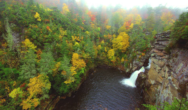
See our Top 12 Waterfalls to see along the Parkway. Above is Linville Falls.
See 15 Quick Hikes on the Blue Ridge Parkway.
Blue Ridge Parkway Mile-By-Mile: Top 50 Things to Do
Here are our top picks for things to do along a 175-mile North Carolina section of the Parkway from north to south. Asheville exits are between Mileposts 382 and 393. Print this list or save it to your phone. Mobile phone service is spotty along the Parkway and most of these places are not listed on GPS.
- Milepost 294, Moses Cone Park: Explore the historic estate with a Mansion, Craft Center and thousands of acres to explore near Blowing Rock. See our Moses Cone Park Guide.
- Milepost 297, Julian Price Park: Walk around, canoe Price Lake, hike, picnic or camp. See our Julian Price Park Guide.
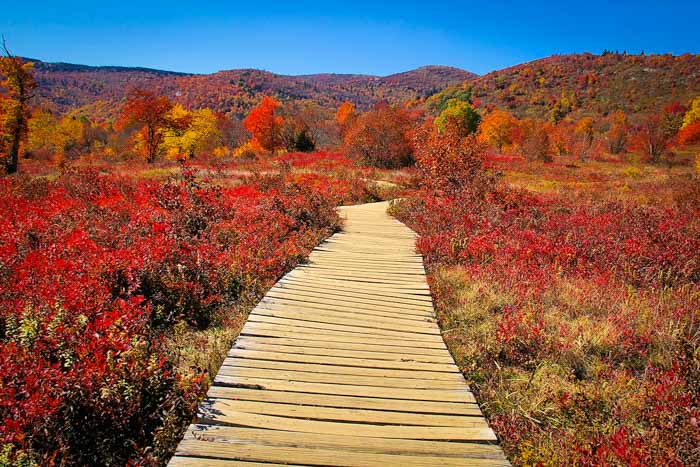
- Milepost 302.8, Rough Ridge: 1/3-mile hike to wonderful views on a boardwalk atop a rocky ridge along Tanawha Trail. See more in our Rough Ridge Hiking Guide.
- Milepost 304.4, Linn Cove Viaduct: This masterpiece of engineering was constructed to preserve Grandfather Mountain, as the viaduct curves with the contours of the mountain. Stop at the Visitor Center and walk under this marvel. See our Linn Cove Viaduct Guide.
- Milepost 305, Grandfather Mountain: Exit onto U.S. 221 to reach this famous mountain. See our Grandfather Mountain Guide. The great town of Banner Elk is 12 miles northwest.
- Milepost 305.2, Beacon Heights: A one-mile roundtrip hike with panoramic views and picnic spots atop a rock face mountaintop. See our Beacon Heights Hiking Guide.
- Milespot 308.3, Flat Rock Trail: A 6/10 of a mile loop hike to a rocky cliff with views of Grandfather Mountain. See our Flat Rock Trail Guide.
- Milepost 312.2: Highway 181 Crosses. Take NC 181 south to hike to Table Rock or Hawksbill Mountain at Linville Gorge. Or go south 5.5 miles for Upper Creek Falls.
- Milepost 316.3, Linville Falls: Take an easy 1 or 1.5-mile hike to see the beautiful falls and gorge. Visitors Center and picnic area. See our Linville Falls Guide. Also see Duggers Creek Falls. Nearby is Linville Gorge.
- Milepost 317.4: US 221 Crosses. Take US 221 South for a faster return to Asheville (to Marion, then I-40 West to Asheville). Linville Caverns is four miles south of the Parkway.
- Milepost 320.8, Chestoa View: Stop and walk a short trail to one of the best views on the Parkway. Elevation 4,090 ft. See our Chestoa View Guide.
- Milepost 328.3, The Orchard at Altapass: A great stop to enjoy mountain music, buy jams, take a hayride through the orchard and buy late summer apples. See our Orchard at Altapass Guide.
- Milepost 331, Museum of North Carolina Minerals (Highway 226): See many local minerals and learn about regional geology (and nice restroom stop!). Free. See our Museum of NC Minerals Guide. Travel north on Highway 226 for six miles to Spruce Pine.
- Milepost 334, Little Switzerland: Stop in this tiny village along the Parkway for food and a little shopping. See our Little Switzerland Guide. Just three miles away is Emerald Village and the NC Mining Museum.
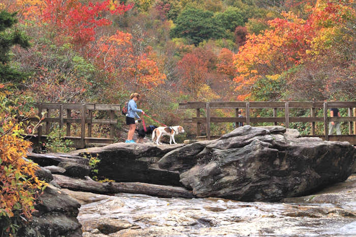
- Milepost 339.5, Crabtree Falls & Meadows: Take a 3-mile moderate hike to the beautiful 70-foot waterfall. Picnic area and campground. See our Guide to Crabtree Falls.
- Milepost 344, NC Highway 80 Crosses: Go south to Marion and I-40 (18 miles). This is the route to Mt. Mitchell during the winter months, weather permitting. Go north on NC 80 to Roaring Fork Falls, Setrock Creek Falls, Burnsville and Toe River Artist Studios. Part of the Mount Mitchell Scenic Byway.
- Milepost 350.4, Green Knob Overlook: Hike to Green Knob Tower.
- Milepost 355.4, Mt Mitchell: Drive 4.6 miles to the top of the tallest mountain east of the Mississippi (6,684 feet) for 85-mile views from the observation deck (if the clouds are not hanging on the peak). Hike through Alpine forests to Mt. Craig or pick up some food at the restaurant and have a mile-high picnic. No admission fee. See our guide to Mount Mitchell State Park.
- Milepost 358.9, Walker Knob Overlook: Park here to hike Big Butt Trail across the high ridges. See our Big Butt Trail Guide.
- Milepost 361.2, Glassmine Falls Overlook: See this skinny 200-foot cascade from across the valley after a good rain. During drier periods, the waterfall almost dries up. Elevation 5,197 feet. See our Glassmine Falls Guide.
- Milepost 364.1, Craggy Dome Parking Overlook and Craggy Pinnacle Hike.
- Milepost 364.4, Craggy Gardens Visitor Center: A popular destination from Asheville (24 miles from downtown) with mile-high spectacular mountain views to the east and west. Enjoy the crisp air, summer rhododendron, and hiking trails. Elevation 5,640 feet. Read more: Craggy Gardens Guide and Craggy Gardens Trail.
- Milepost 367.6, Craggy Gardens Picnic Area: Ample parking, lots of picnic tables, and easy access to several trails make this a favorite destination. Also a great place for stargazing.
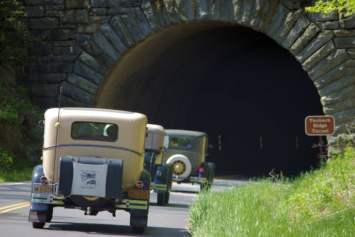
- Milepost 375: Tanbark Ridge Tunnel and parking area for Rattlesnake Lodge hiking trail.
- Milepost 376.6: Ox Creek Road intersects and winds down into the valley. At the end of Ox Creek Road (four miles), take a left on Reems Creek Road to go into the Weaverville area. Take a right on Reems Creek to visit Vance Birthplace State Historic Site.
- Milepost 377.4: Turn onto NC 694 (not marked from the Parkway) for a fun drive on Town Mountain Road into downtown Asheville. You can hike on the Mountains to Sea trail from the small parking area there.
- Milepost 382, Folk Art Center: See and buy some of the finest art and crafts from Southern Appalachian artists. Browse the three fine art galleries, see daily craft demonstrations, and visit the Parkway information center. Read more about the Folk Art Center.
- Milepost 382.6: Asheville, US 70 crosses. Go east to find I-40 East and Black Mountain (10 miles). Head west into Asheville.
- Milepost 384, Parkway Visitor Center: Get plenty of info, see exhibits and watch a great high definition film.
- Milepost 384.7: Asheville, US 74A crosses. Head east to Chimney Rock State Park and Lake Lure (25 miles). Head west to find I-40 West.
- Milepost 388.8: Asheville, US 25 crosses. Travel north three miles to Biltmore Estate or south for I-26 South toward Hendersonville.
- Milepost 393.6: Asheville, NC 191 crosses. Go north for Asheville and I-26. Exit here for the NC Arboretum (adjacent to Parkway) and Bent Creek Mountain Biking and Lake Powhatan Camping.
- Milepost 404.5, Mills River Valley Overlook: Our favorite spot to watch sunrises over many mountain ridges and valley fog.
- Milepost 407.6, Mt. Pisgah: The trail to the summit of this 5,721-foot peak may be a bit strenuous, but the reward is the view from the top. Picnic area at Milepost 407.8. See our Mount Pisgah Hiking Guide.
- Milepost 408.7, Pisgah Inn: The only inn and restaurant on this stretch of Parkway is located at 5,000 feet. It's a great place to stop for lunch since their dining room has big windows with beautiful vistas. Campground also. Open April through October. Read more.
- Milepost 409.6, Fryingpan Mountain Lookout Tower: Forest Service Road 450. 1.5-mile roundtrip hike to the lookout tower affords a better view than neighboring Mt. Pisgah. Read more about Fryingpan Mountain Tower.
- Milepost 412: US 276 crosses. Forest Heritage Scenic Byway. Take a beautiful drive south through Pisgah National Forest to Pink Beds Hike (4 miles), Cradle of Forestry (4 miles), Sliding Rock (8 miles), Looking Glass Falls (10 miles) and Brevard (18 miles). Head north to Waynesville (22 miles).
- Milepost 412, Cold Mountain Overlook: Elevation at overlook, 4,542 feet. Read more about Cold Mountain.
- Milepost 413.2 Pounding Mill Parking Overlook: Our top spot to watch the monarch butterflies as they migrate to Mexico in early fall.
- Milepost 417, Looking Glass Rock Overlook & Skinny Dip Falls: Named for reflecting light brilliantly when water and ice are on the rock's granite surface. From overlook, hike 1/2 mile to Skinny Dip Falls, a popular summer swimming spot. Hike to the top of Looking Glass from U.S. 276.
- Milepost 418.8, Graveyard Fields: This barren scenery is very different from what you see along most of the Parkway. Enjoy nice vistas with fairly easy hiking to some waterfalls. However, it can become very crowded here. Elevation 5,120 feet. Read more about Graveyard Fields.
- Milepost 420.2, Black Balsam: Two spectacular hikes across bald mountains above 6,000 feet elevation for sweeping vistas: Black Balsam Knob and Sam Knob.
- Milepost 422.4, Devil's Courthouse: Take a strenuous 1/2-mile hike to the "Courthouse" for a 360-degree view. See our Devil's Courthouse Guide and Photos. Elevation at parking area, 5,462 feet.
- Milepost 423.2: NC Highway 215 Crossover. Go north to Canton, then back to Asheville. The trailhead for the Cold Mountain summit hike is 13 miles north. Also north is Wildcat Falls and Sunburst Falls. Go south on NC 215 for more waterfalls: Dill Falls, Courthouse Falls and Cathedral / French Broad Falls. This is the Forest Heritage Scenic Byway. Pisgah Astronomical Research Institute (PARI) is a must for space and science lovers.
- Milepost 430, Cowee Mountains Overlook: At an elevation of 5,950 feet, stunning mountain views and one of the best places on the Parkway to watch a sunset.
- Milepost 431.4, Richland Balsam Overlook: Stop at the highest point on the Blue Ridge Parkway (6,047 feet), and hike a 1.5-loop to the summit. See our Richland Balsam Guide.
- Milepost 443.1: Balsam Gap, US 74/23 Crossover. For a fast route back to Asheville, follow US 74 east to Waynesville, then I-40 east to Asheville. Head south to Sylva and Jackson County.
- Milepost 451.2, Waterrock Knob: Stop here for lofty views from the parking area and hike to the summit of one of highest peaks along the Parkway. Visitor Center and restrooms. Another popular spot to watch the sunset. See our Waterrock Knob Guide.
- Milepost 455.7: Soco Gap, US Highway 19 exit to Maggie Valley or Cherokee & Harrah’s Cherokee Casino. Drive south on Highway 19 for 1.5 miles to Soco Falls, a 120-foot twin waterfall.
- Milepost 458.2, Heintooga Road: Spur road to a mile-high overlook. Go 12 miles to Balsam Mountain Campground in the Great Smoky Mountains. Read more about Balsam Mountain and Heintooga Round Bottom Road.
- Milepost 469.1: Blue Ridge Parkway ends at US 441 at the Great Smoky Mountains National Park near Cherokee. Visit the Oconaluftee Visitors Center to plan your visit to the Smokies.
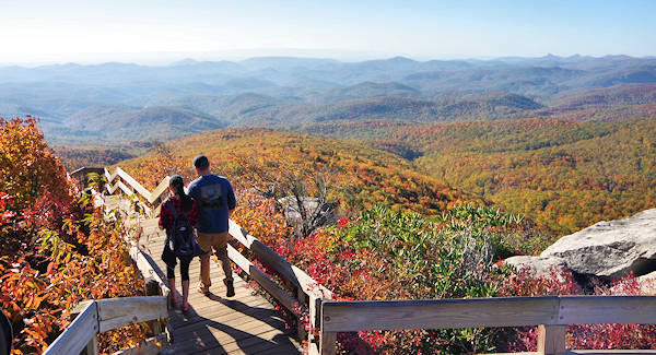
Hiking: Find hundreds of miles of hiking trails. Many overlooks have connecting trails. Since signage is limited, plan ahead. See our Top 15 Quick Parkway Hikes. For more options, see our Asheville Top 75 Hikes. Pic: Rough Ridge.
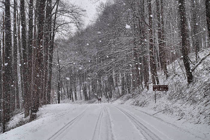
Tips for Driving the Parkway: Since this is not your typical road, see our tips for taking this scenic route (along with latest construction or closures). It's all about the drive. Take it slow and stop at the many overlooks to enjoy the views. Don't depend on GPS since many places do not have an accurate street address. For Parkway questions, call the Blue Ridge Parkway information line: 828-348-3400.
Getting on the Parkway in Asheville: Take the Blue Ridge Parkway north or south from Asheville, and in either direction you will quickly climb the ridge and reach elevations of 5,000+ feet. Keep in mind that the higher stretches of the Parkway are closed during the winter months (November-March), depending on the weather. There are five entrances to the Parkway in the Asheville area. If you are taking the Parkway to the north, take the entrance from U.S. Highway 70 east of town (at Blue Ridge Parkway Milepost 382), and if you are heading south, take the entrance from NC Highway 191 near I-26 (at Blue Ridge Parkway Milepost 393). There are no exits to the Blue Ridge Parkway from interstate highways. While the Parkway is open 24 hours a day, facilities along the way operate on a seasonal schedule.
Biking: The Parkway is a popular biking route, so watch for bicyclists! See our Biking Tips for the Parkway.
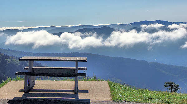
Picnics: See the best places for Parkway Picnics, along with tips.
Waterfalls: Find our 12 favorite Parkway waterfalls along or within a 10-mile detour.
Weddings: Read about eloping on the Parkway.
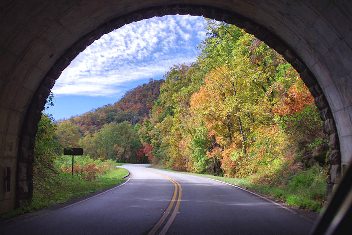
Fall Foliage: Calling all leaf peepers–take a look at our Fall Color Forecast to get expert tips on the best time to plan autumnal scenic drives on the Blue Ridge Parkway in Western North Carolina.
Map: See a map of the Asheville area of Parkway. Also, download a PDF of the official Blue Ridge Parkway Map (15 MB).
Driving Tour Suggestions
From Asheville take a leisurely ride on the Blue Ridge Parkway north or south. Then take a "regular" highway for a fast return to Asheville.
- The North Loop: Drive north from Asheville to Milepost 304.4 (about 80 miles - allow three hours), ride across the Viaduct and turn around to return to Milepost 317.4. Exit onto US 221 South to Marion, then take I-40 West to Asheville. The return trip is about 1.5 hours.
- The South Loop: Drive south from Asheville about 50 miles to Milepost 443.1 (allow 2.5 hours). Take US 74 East/US 23 North to Waynesville, then I-40 East to Asheville. Return trip is about an hour.