Limited-Time Offer: Save $50 on a Biltmore® Annual Pass
Buy Your Pass
Cold Mountain, North Carolina, located 35 miles from Asheville, has received notoriety from the best-selling Charles Frazier novel Cold Mountain and the acclaimed 2003 motion picture. The movie was filmed in Romania; however, the mountain scenery is very similar to the real Cold Mountain area. There is not an actual town of Cold Mountain. The mountain itself (elevation 6,030 feet) is part of the Shining Rock Wilderness area in Pisgah National Forest. Since Cold Mountain is in a national forest, it is still in its natural state (much as it was during the Civil War) and requires a strenuous 10-mile roundtrip hike to reach its summit. However, you can enjoy beautiful views of the mountain from your car via the Blue Ridge Parkway or a shorter hike to the top of Mount Pisgah (see below).
Seeing and Hike to Cold Mountain
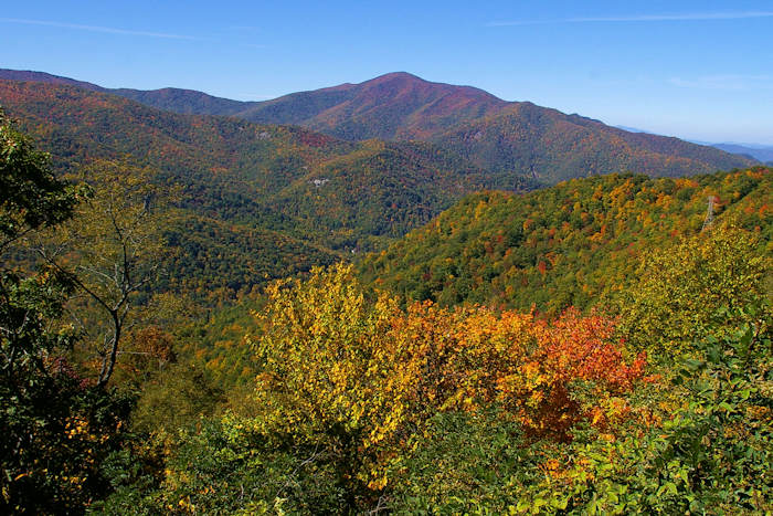
The easiest way to see Cold Mountain is from the Blue Ridge Parkway at Milepost 412, about 30 miles from downtown Asheville. You can view the south side of Cold Mountain from an overlook near the U.S. Highway 276 exchange at Milepost 411.9. The views from the overlook are spotty with overgrown trees blocking most of the view. For the best view, go to the Wagon Gap Road Parking area at Milepost 412.2. Then walk north on the Parkway a short distance (see top photo).
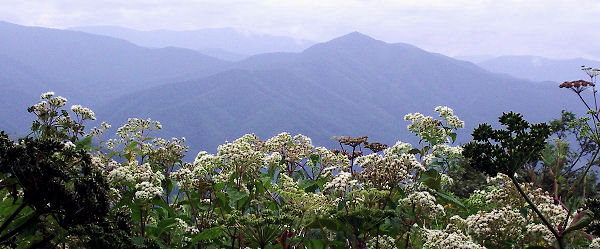
View of Cold Mountain from Mt. Pisgah
A more extensive view of Cold Mountain is enjoyed from the top of Mount Pisgah (5,700 feet), located at Milepost 407 on the Blue Ridge Parkway, 26 miles southwest of Asheville (read about the Mt. Pisgah hike). A 3-mile roundtrip hike takes you to the top for a grand view of Cold Mountain. The hike is a bit strenuous, but the view will be a nice reward.
Another extensive view via an easier hike (1.5 miles roundtrip) is from Fryingpan Mountain Lookout Tower. Read about the Fryingpan Tower hike.)
Note: This section of the Blue Ridge Parkway is closed for much of the winter depending on the weather, usually November through March. During these months, you can call 828-298-0398 (Asheville local call) for weather and road closure information. Even when the Parkway is closed, the Cold Mountain overlook is accessible from U.S. 276 exchange.
Hiking to the Cold Mountain Summit
See photos of the summit hike to Cold Mountain. The quickest way to reach the summit of Cold Mountain is via a 10.6-mile strenuous roundtrip hike in a wilderness area of the Pisgah National Forest. The hike includes a 3,000 foot altitude gain to the 6,030-foot peak. Chances are good that you will see few people on the entire hike. The trailhead for the hiking trail (Art Loeb Trail) is located at the Daniel Boone Scout Camp.
The Art Loeb Trail to the Cold Mountain summit goes to the left from the parking area just after the Scout camp's last building. Leaving the roadside, the Art Loeb Trail switchbacks north to round a ridgeline at 1.1. miles. At 2.0 miles, the trail crosses tumbling Sorrell Creek at the first good campsites. The trail continues to rise across the richly forested flank of the Shining Rock Ledge. At 3.8 miles, take a left at Deep Gap. The peak is 1.5 miles north.
Since the hike is in a wilderness area, there are no signs or trail markers. Only experienced, in-shape hikers should tackle this mountain. The trail is well-worn, so it's fairly easy to follow. Read more about the Cold Mountain hike.
Cataloochee Valley
This area of the Great Smoky Mountains National Park (called "Catalucci" in the novel) will give you a glimpse of life in the 1800s. This beautiful valley has several original structures, and you can watch the elk from your car! Read more about Cataloochee Valley.
Scenic Driving Loop
This approximately 85-mile loop drive combines the two below routes for the beginning of the Cold Mountain hiking trail. It is a beautiful, hilly, curvy drive through a very rural mountain area. Allow 3-4 hours. As noted earlier, this section of the Blue Ridge Parkway is closed for much of the winter.
- Travel south on the Blue Ridge Parkway. For the best view of Cold Mountain, stop to hike Mt. Pisgah at Milepost 407. Continue south on the Blue Ridge Parkway, stopping at Cold Mountain overlook at Milepost 411.9. (See above "Best Places to View.")
- At Milepost 423.2, take NC Highway 215 north for 13 miles.
- If you want to drive an extra 8 miles roundtrip to go to the base of the hiking trail, turn right onto Little East Fork Road. Views of the mountain are limited.
- Continue for 5 miles. NC Highway 215 will turn into Highway 110. Continue 5.3 miles.
- In Canton, turn right onto Highway 19/23 north.
- Turn left onto Church Street, and right on Newfound Road.
- Go 1.6 miles to I-40 East to return to Asheville.
Nearby are many waterfalls: French Broad / Cathedral Falls, Courthouse Falls and Dill Falls.


