Limited-Time Offer: Save $50 on a Biltmore® Annual Pass
Buy Your Pass
Enjoy the Blue Ridge Parkway by exploring some of its many hiking trails near Asheville. There’s a big variety of hikes, ranging from easy strolls to strenuous climbs. Since finding the perfect day hike that offers plenty of mountain scenery can be a challenge, we've put together our list of the Top 15 Quick & Easy Parkway Hikes. All of these hiking trails are easy to find and less than four miles while providing plenty of rewards for all fitness levels. For a full-page guide with photos of each hike, click the links.
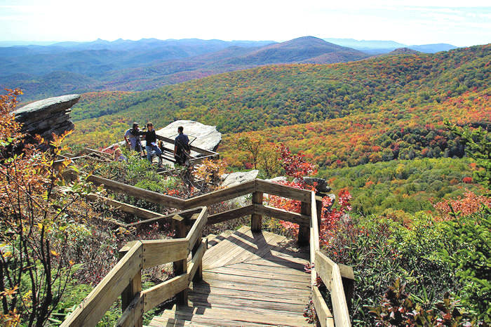
These hikes are located at various spots along a 120-mile stretch of the Blue Ridge Parkway near Asheville, starting from the north near Grandfather Mountain and working south. During the winter months, these trails are often inaccessible since sections of the Parkway often close for snow and ice. Also, find biking tips at the bottom. Read more about current Parkway closures. (Photo above: Rough Ridge)
Blue Ridge Parkway Ranger Guided Hikes near Asheville
If you prefer a guided group hike, meet up on Friday mornings during the summer and fall with a Park Ranger. They usually announce locations about 10-14 days in advance, so check back here for the latest options during summer and fall. Bring water, wear sturdy shoes or boots, and prepare for changing weather. For more information, call 828-298-5330, extension 304. Free admission.
Parkway Quick Hikes near Asheville (North to South)

Black Balsam Knob
(1-10 miles, moderate) For sweeping 360-degree views, hike across these bald mountaintops. Almost entirely devoid of trees above 6,000 ft., the summit is more reminiscent of New England than North…
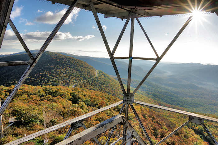
Fryingpan Tower
(1.5 miles round-trip, moderate) See panoramic views of Pisgah National Forest from atop the historic fire tower near Mt Pisgah. Blue Ridge Parkway Milepost 409.6.
Beacon Heights
(1 mile round-trip, easy) A quick walk to the summit has a big payoff with spectacular views from several rock platforms to explore safely. Take a picnic! Blue Ridge Parkway Milepost 305.

Craggy Gardens Trail
[CURRENTLY CLOSED] (1 mile, easy) Walk across a mile-high bald filled with rhododendron, wildflowers and mountain views. Access the trail from the Craggy Picnic Grounds or Visitor Center (Milepost…

Mt. Mitchell Deep Gap Trail to Mt. Craig
(Up to 9 miles round-trip, moderate) Our favorite quick hike at Mount Mitchell is the Deep Gap Trail to Mt. Craig, a two-mile round-trip hike. Continue on the Deep Gap Trail for another 3.5 miles…
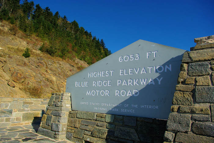
Richland Balsam
(1.5-mile loop, easy) Hike the top of the highest summit along the Blue Ridge Parkway in the cool forest. Blue Ridge Parkway Milepost 431.

Crabtree Falls
(3 miles round-trip, moderate) This gorgeous 70-ft. waterfall along the Blue Ridge Parkway (Milepost 339), near Linville Falls, is accessed by a very scenic, loop woodland hiking trail.

Flat Rock Trail, Blue Ridge Parkway
(6/10 mile, easy) Hike a loop trail to a flat rock summit with expansive views and great picnic spots. Hidden away at Milepost 308.3 on the Blue Ridge Parkway - near Linville Falls.

Linville Falls
Perhaps the most photographed waterfall in NC, Linville Falls (a.k.a. the “Grand Canyon of the Southern Appalachians”) is along the Blue Ridge Parkway (Milepost 316). A moderate hike of…

Devil's Courthouse
(1 mile round-trip, moderate) This short-but-steep trail climbs a half-mile to the peak for spectacular views. The bare rock profile named Devil's Courthouse is sinister in appearance and legend.…

Rough Ridge
(1.5 to 8 miles round-trip, moderate to strenuous) This unique hike offers plenty of breathtaking viewpoints and a wooden boardwalk over fragile vegetation. The Tanawha Trail features many rock…

Graveyard Fields
(1-4-mile options, moderate) This very popular spot features two waterfalls in a mile-high valley filled with wildflowers and surrounded by Blue Ridge Mountains' 6,000-ft. peaks. Second Falls is…

Big Butt Trail
(4.5 miles round-trip, strenuous) This lofty hike keeps you above 5,000 ft. elevation as you hike to Point Misery and Little Butt, so it's perfect for a hot summer's day. On the Blue Ridge Parkway…

Waterrock Knob
(2.4 miles round-trip, strenuous) Hike to the summit (6,292 ft.) of the 16th highest mountain in the eastern United States. Blue Ridge Parkway Milepost 451.

Mount Pisgah
(3 miles round-trip, strenuous) Mount Pisgah can be seen from downtown Asheville on a clear day. Hike up to the top of the 5,721-ft. summit on this popular hiking trail. Blue Ridge Parkway…
Craggy Pinnacle
[CURRENTLY CLOSED] (1.4 miles round-trip, strenuous) For our favorite 360-degree mountain view along the Blue Ridge Parkway, hike to the top of this 5,892-ft. peak at Craggy Gardens. Trailhead at…
Hiking Trails on the Blue Ridge Parkway: Complete List
Stop at any of these mileposts on the Blue Ridge Parkway in the Asheville, North Carolina, area for a hike (listed north to south). Click links for more details!
- Milepost 294 Moses Cone Manor, variety of trails.
- 297 Price Lake Loop Trail, easy walk of 2.3 miles.
- 302.8 Rough Ridge 3/4-mile with wonderful views on a boardwalk atop a rocky ridge, on Tanawha Trail.
- 304.4 Linn Cove Viaduct Visitor Center and Tanawha Trail.
- 305.2 Beacon Heights Trail, one mile round-trip with panoramic views from a rock face mountaintop, on Tanawha Trail.
- 308.2 Flat Rock Trail: Loop with panoramic views from rock summit. 0.63 mile, easy.
- 316.4 Linville Falls Trail: Trails to multiple overlooks of the waterfall and Linville Gorge. 1-4 miles.
- 320.8 Chestoa View Trail: 30-minute loop to vista. 0.6 mile. easy.
- 339.5 Crabtree Falls: Loop trail to view waterfalls. 3 miles, strenuous.
- 350.4 Green Knob Lookout Tower. A tower with 360-degree views is a 1/2-mile hike. Moderate/strenuous.
- 355.4 Mt. Mitchell State Park & Mt. Craig.
- 359.8 Big Butt Trail: Highland trail to Pt. Misery and Little Big Butt. 6.2 miles, strenuous.
- 361.2 Glassmine Falls: Just a few steps out of the parking area to a view of Falls. 0.05 mile, moderate.
- 364.2 Craggy Pinnacle Trail: See a spectacular panoramic view from the summit. 0.7 mile, moderate.
- 364.6 Craggy Gardens Trail: Beautiful displays of Catawba Rhododendron bloom in June. 0.8 mile, moderate.
- 374.4 Rattlesnake Lodge Trail: Woodland walk up the ridge to old homestead site, now just walls and foundations. 0.5 mile, moderate.
- 382.0 Mountain-to-Sea Trail: MTS Trail from Folk Art Center to Milepost 365. The Mountain-to-Sea Trail roughly parallels the Parkway through most of the NC mountains.
- 393.7 Shut-In Trail/MTS Trail: Bent Creek-Walnut Cove. 3.1 miles, strenuous.
- 396.4 Shut-In Trail/MTS Trail: Walnut Cove-Sleepy Gap. 1.7 miles, moderate.
- 407.6 Mt. Pisgah Trail: Hike to summit view from 5721 ft.. 1.3 miles, strenuous.
- 407.6 Buck Springs Trail: Pisgah Inn Lodge to view. 1.06 miles, easy/moderate.
- 408.5 Frying Pan Mountain Trail: Historic fire tower with views. 3/4-mile trail, moderate.
- 417.0 Skinny Dip Falls: Park at Looking Glass Rock overlook for 1/2-mile hike to popular summer swimming hole.
- 418.8 Graveyard Fields Loop Trail: Loop by a stream with several waterfalls. 2.3 miles, moderate.
- 420.2 Black Balsam Bald & Art Loeb Trail. Outstanding hike across the balds with several hike options. 1-5 miles.
- 422.4 Devil's Courthouse Trail: Panoramic summit view. 0.4 mile, moderate/strenuous.
- 431.0 Richland Balsam Trail: Self-guiding loop through spruce-fir forest near the highest point on the Parkway. 1.5 miles, moderate.
- 451.2 Waterrock Knob Trail: Summit view. 1.2 miles, moderate/strenuous.
Blue Ridge Parkway Biking Rules & Regulations
- Bicycle riders must comply with all applicable state and federal motor vehicle regulations.
- Bicycles may be ridden only on paved road surfaces and parking areas. Bicycles, including mountain bikes, may not be ridden on trails or walkways.
- The bicycle operator must exhibit a while light or reflector visible at least 500 feet to the front and a red light or reflector visible at least 200 feet to the rear during periods of low visibility, between the hours of sunset and sunrise, or while traveling through a tunnel.
- Bicycles must be ridden single file except when passing or turning left and well to the right-hand side of the road.
- Bicycle speed must be reasonable for control with regard to traffic, weather, road and light conditions.
Bicycling Tips
- Wear a bicycle helmet.
- Watch out for tourists driving their cars and looking at the scenery instead of the road.
- Be sure your bicycle is in good operating condition. Carry a spare tube and tools for minor repairs.
- Take a cell phone. However, you will not have good reception in many remote areas.
- Wear high visibility clothing. It sets you apart from the scenery and makes you more visible to motorists.
- Avoid the Parkway during periods of low visibility. Fog and rain may occur unpredictably.
- Exercise caution when riding through tunnels. Please be sure your bicycle is equipped with the proper lights or reflectors. When you go from bright sunshine to a dark tunnel, your eyes will not adjust fast enough to see the road. So go slow or walk your bike. There are no lights in the tunnels.
- Temperatures vary greatly along the Parkway due to different elevations. Wear your clothing in layers, if possible.
- Safe drinking water is available at all picnic areas, campgrounds, concession operations, and visitor centers. But these are far apart. Water from streams and springs is unsafe for drinking unless you purify it.
- Make an honest evaluation of your abilities before beginning a bicycle trip on the Parkway. In some sections, you will climb as much as 1,100 feet in 3.4 miles.
- Ride single file. When cycling in a group, adjust your spacing to allow motor vehicles to pass safely.


