Limited-Time Offer: Save $50 on a Biltmore® Annual Pass
Buy Your Pass

Dry Falls, a popular waterfall located a few miles outside of Highlands, gives you the rare treat of walking safely behind a waterfall. This 75-ft. tall waterfall in the Nantahala National Forest flows over a cliff, allowing you to walk behind the falls and stay dry (hence the name). During rainy spells when the water volume is higher, the spray will prevent you from staying totally dry. There is small a fee for this falls.
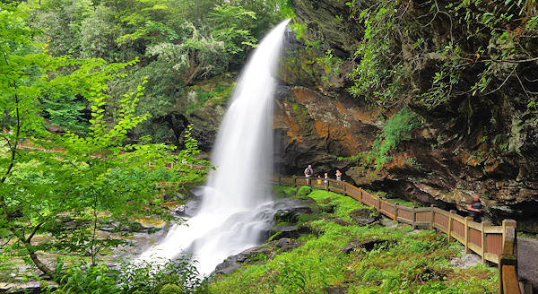
Located roadside on US Highway 64, everyone can enjoy the view from a fully accessible observation area adjacent to the parking area. It's a short walk down the trail to reach the falls. The view above is from the end of the short trail.
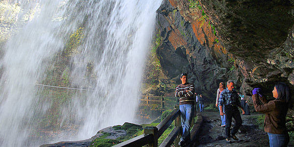
The real treat is getting a closer look by climbing down the stairs and walking the short path. There are many great vantage points along the way for photos. You may be able to see a rainbow if you and the sun are in the right positions. The spray from the falls may get you a little wet when you walk behind it, so have somewhere to hide your camera or anything you don't want to get wet. But it’s usually just a little mist.
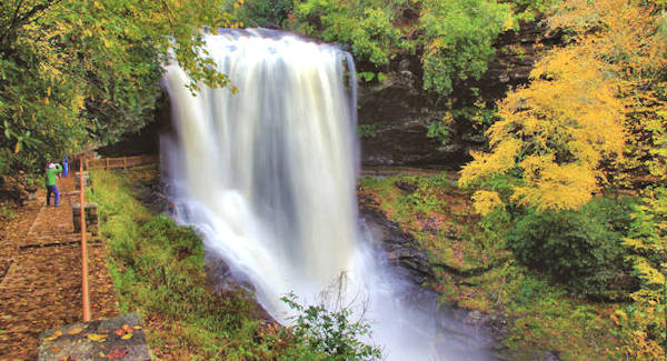
Fall peak color in this area is usually the second week of October. See more on our Fall Foliage Guide.
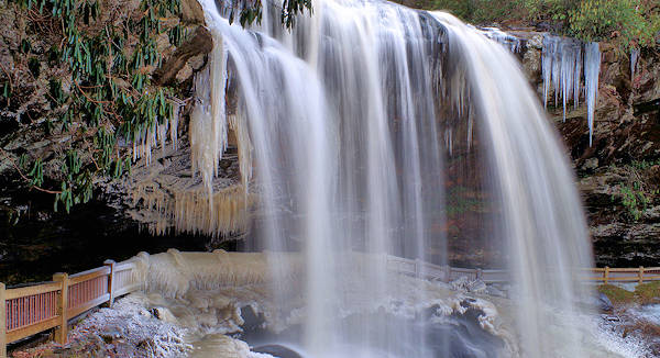
During the coldest winter periods, stop by to see the ice formations! When there's ice, the section behind the waterfall is blocked off for safety.
Dry Falls flows on the Cullasaja River through the Nantahala National Forest. It is part of a series of waterfalls on a 8.7-mile (14 km) stretch of the river that eventually ends with Cullasaja Falls. In the narrow and deep Cullasaja Gorge, the Cullasaja River rushes and drops in a series of cascades and waterfalls to the Tennessee River near Franklin. A two-lane highway called Mountain Waters Scenic Byway, the combined route of U.S. 64 and NC 28, runs through the Cullasaja Gorge, which is mostly protected as part of the Nantahala National Forest.
The U.S. Forest Service has designated this to be a National Scenic Byway because of the river, and its numerous waterfalls. The highway clings to the north bank of the Cullasaja River. Though the road is narrow and the curves are frequent and sharp, it can be a fun and beautiful drive. There are many places to pull off, get out and enjoy the views of the river.
It's approximately 80 miles from Asheville, so it makes a great day trip with much to see along the way.
Nearby Waterfalls
Less than a mile away from Dry Falls, drive behind Bridal Veil Falls. Also nearby are hikes to Glen Falls and Secret Falls. A short drive away on US 64 is Bust Your Butt Falls swimming hole and Cullasaja Falls. Read more about in our Highlands & Cashiers Waterfalls Guide. And for more waterfalls in the Asheville area, see our Waterfalls Guide.
Directions
Coming from Highlands: Take Hwy 64 west for just over 3 miles from its intersection with Hwy 106. Pass or stop at Bridal Veil Falls, then look for a brown and white forest service sign for Dry Falls and turn left into the parking area. If you are coming from Franklin, Dry Falls is about 16.5 miles east on U.S. Hwy 64.
From Asheville: Take I-40 West to route 23/74W towards Waynesville. Take 23/74W to 23/441 towards Dillsboro, Sylva and Franklin. At Franklin stay on the bypass and take U.S. Highway 64 East toward Highlands. 82 miles, 1.5 hour drive.
Video of Dry Falls after a big rain:


