Limited-Time Offer: Save $50 on a Biltmore® Annual Pass
Buy Your Pass

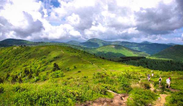
A must-hike along the Blue Ridge Parkway (milepost 420.2, about 26 miles from Asheville) is the Black Balsam Knob area, which includes some of the most spectacular mountain balds in the Southern Appalachians, including Black Balsam Knob (or Black Balsam Bald), Sam Knob and Tennent Mountain. These treeless mountaintops in the Pisgah National Forest draw people from all over to soak in the sweeping views with an alpine-like feel. Almost entirely devoid of trees above 6,000 ft. elevation, the summits are more reminiscent of New England than North Carolina.
Walk almost three miles on the balds without dropping back into the trees. With views similar to those iconic "Sound of Music" scenes, you may be singing "The Hills Are Alive." It's definitely unique for our area. At 6,214 ft., Black Balsam Knob is the 23rd highest of the 40 mountains in North Carolina over 6,000 ft. The trailhead is not accessible much of the winter since the Parkway often closes for snow or ice.
Hike Options
There are many options for hikes in this area, and you only have to hike a half-mile to reach the first balds. So you can hike as little or as much as you want. Take a picnic! The trail is rutted out in many locations and rocky in others. The section past Tennent Mountain descends quickly on a rocky trail that can be tough on the knees.
5 Mile Loop: Our favorite is a loop that climbs and descends several balds, ending with a mostly level walk back. To reach the trailhead, drive about 7/10 of a mile down the road from the Blue Ridge Parkway (more directions below) and look for paved parallel parking on the right. Park there and look for the "Mountains to Sea Trail" marker.
- Take a few steps to the beginning of the Art Loeb Trail.
- Walk about 1/2 mile through the alpine forest to reach the open, grassy and rocky mountain meadows. Cross a small bald and continue to Black Balsam Knob in another 1/2 mile.
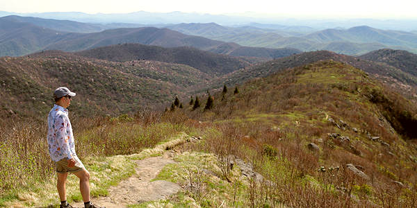
- Atop Black Balsam, see the marker for Art Loeb, then turn left to stay on the main trail to Tennent Mountain (elevation 6,040 ft.) in another half mile. You'll know you are there since there's a plaque at the top - a total of 1.5 miles from your car.
- You'll pass another knoll en route to Tennent. At the foot of the knoll, you'll see a fork in the trail. Go left to stay on the White Blazed Trail to loop around the bald. Or, stay right to cross the top with a more rocky trail that is rough on the knees.
- From Tennent, continue for just over a half-mile to the intersection of Ivestor Gap Trail. You will cross a small bald and then head down the ridge to a very obvious intersection. Turn left on Ivestor Gap Trail, a former road with a mostly level hike that takes you back to the parking area at the end of the Black Balsam Road.
- To get back to your car, walk the paved road a half-mile to your car (easier option) from the parking area or hike the strenuous one-mile Art Loeb Connector trail to the top of the first bald to complete a loop. When you reach the Art Loeb Trail atop the bald, turn right to get back to your car. See the map below!
Sam Knob: Continue to the end of Black Balsam Knob Road for restrooms and a larger parking area. Read about the Sam Knob Hike that begins here.
View from atop Tennent Mountain
Tips
Since most of the trail is not protected by any trees, be sure to wear sunscreen! And hike early in the morning for fewer people to share this amazing place with. It's usually 15-20 degrees cooler than in Asheville. And the summits are often covered by passing clouds. Summer afternoon storms and low clouds are typical. To cool off after a hike, go to nearby Skinny Dip Falls (three miles north on the Parkway).
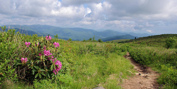
Spring arrives late and fall arrives early at this high elevation. Green and leaves don't appear until May and fall color is early October. The many rhododendron bloom in late May and early June.
Camping
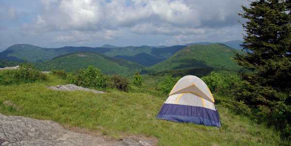
Excellent camping spots can be found on top of the balds (stay 1,000 ft. away from the trail), but beware of fast-changing weather that is often 20 degrees cooler than in Asheville. Campfires are not allowed within the Shining Rock Wilderness boundaries, so bring a camp stove. Due to bear activity, food storage is required to be in a commercially-made canister constructed of solid, non-pliable material manufactured for the specific purpose of resisting bears. Call the Pisgah Forest ranger station before you go to get latest advisories at 828-877-3265. If you are looking for more modern facilities, the Parkway operates the Mt. Pisgah campground during the summer, 11 miles to the east.
Driving Directions
From the Blue Ridge Parkway, look for the "Black Balsam" sign near milepost 420, just south of Graveyard Fields and north of Devil's Courthouse. It's about 26 miles from the NC 191 Parkway entrance in Asheville (NC Arboretum). It's a super-scenic drive with plenty of overlooks along the way, so allow about an hour to drive. For the 5-mile loop, drive about 7/10 of a mile down the road and look for the trail on the right. Continue another half mile for restrooms and other trails. This section of the Parkway is often closed in the winter for ice and snow. See Parkway closure updates.
Similar hikes are Roan Mountain and Max Patch.
Check out this 360 video of Black Balsam Knob View by our friends at Hike NC With Me
Balsam Knob Trail Map
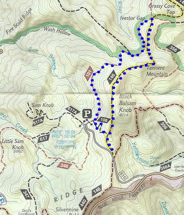
Follow the blue dots for the 5-mile loop hike to Black Balsam Knob via Art Loeb Trail (#146), Tennent Mountain and Ivestor Gap Trail (#101). The Ivestor Gap Connector Trail is #108.


