Limited-Time Offer: Save $50 on a Biltmore® Annual Pass
Buy Your Pass

The Trombatore Trail is a new, beautiful woodland hike to the grassy summit of Blue Ridge Pastures (elevation 3,780 feet). The 2.5-mile trail (5 miles roundtrip) was completed in late 2014. It's super convenient to Asheville (19 miles from downtown) and along the US 74A route to Chimney Rock. It's adjacent to another great hike to through a mountaintop pasture at Bearwallow Mountain. Thanks to the Conserving Carolina for securing the land and their hard-working volunteers for creating this trail that will one day be part of the much longer Upper Hickory Nut Gorge Trail to a network of trails at Florence Nature Preserve.
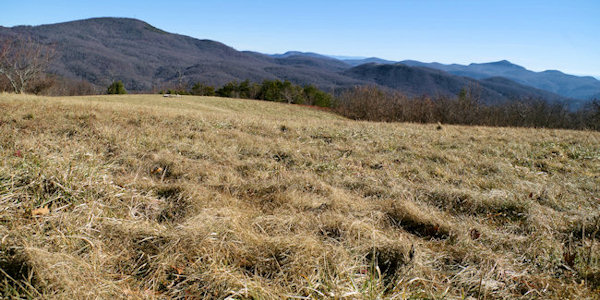
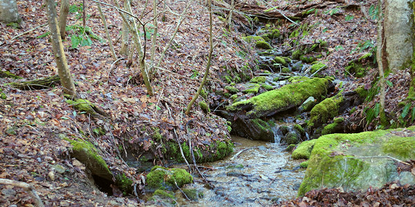
The reward at the end of the strenuous trail (climbs 1,200 feet in elevation) is a sweeping views of the surrounding mountains, from Mt. Mitchell to the north to neighboring Bearwallow Mountain to the south, with the rim of the Hickory Nut Gorge to the east. The first mile of the trail through the Upper Brush Creek watershed descends via generous switchbacks. This watershed along the Eastern Continental Divide feeds Lake Lure. At about 4/10 of a mile, pass a unique curvy tree on the left. About 100 yards farther, look below to the right to see a 150-year giant that was spared by loggers that harvested the area a few decades back.
The trail is easy to follow with signs posted at various turns along the way. Sections of the trail follow an old logging road. Most of the final 1.5 miles of the trail is uphill with a few steeper sections. Near the summit, you'll climb over a barbed wire fence thanks to a wooden stile. Then you'll enter the pasture and continue to a fire pit with a few logs to rest and soak in the views. It's a great setting for a picnic, often with migratory songbirds serenading you.
Across the road from the start of the Trombatore Trail is the one-mile hike to the top of Bearwallow Mountain. So you could combine both for a strenuous 7-mile roundtrip hike. Read more about the Bearwallow Mountain Hike.
Trombatore Virtual 360 Hike
See the following video filmed by our friends at Namaste In Nature! This video was filmed using 360º 5.6K resolution so you may need to adjust your youtube streaming quality to a higher setting for the best experience. These videos work on a desktop but seem to stream better on a mobile device.
Driving Directions
GPS N35.4607, W-82.3681 (Note: Use the below directions and don't depend on GPS since some systems don't pick up the unpaved road!)
From Downtown Asheville: Take I-240 east for continue straight onto US Hwy. 74-A East toward Chimney Rock. Follow 74-A East for about 12.5 miles (up a very long set of switchback curves) to the town of Gerton. Turn right on Bearwallow Mountain Road and go 2.1 miles to the top of the ridge and park on the side of the road (where pavement starts). There is space for parallel parking on both sides of the road. You'll see the Bearwallow Mountain Trail on the left and the log steps to the Trombatore Trail on the right. This road is unpaved, but all cars should make it fine. This road continues down the mountain on the other side and eventually takes you to US 64 near Hendersonville.
Nearby: Wildcat Rock Trail
Conserving Carolina
Since 1994, they have protected 42,000+ acres in more than 150 projects in WNC, from the waterfalls of DuPont State Forest, to the rock faces of Hickory Nut Gorge, to the farms and… More Information


