Limited-Time Offer: Save $50 on a Biltmore® Annual Pass
Buy Your Pass

Lover's Leap is a rock outcropping on the Appalachian Trail in Hot Springs. It offers a spectacular panoramic view of the French Broad River and Pisgah National Forest. Since the famous Appalachian Trail (AT) goes through the tiny town of Hot Springs, you can hike from the center of downtown for a very scenic 2-mile loop. Find free public parking for hikers along Andrews Avenue (turn right from Bridge Street after you cross the railroad tracks). It's 36 miles / 45 minutes from downtown Asheville.
While you can hike the loop in less than an hour, allow plenty of extra time to enjoy the views along the way. We rank the hike as "moderate" since you are walking up the ridge, gaining about 500 feet in elevation. But it's a gradual climb. While the legend is that a lovesick woman jumped from the rock, it's not the place for leaping!
Take a short detour to legendary Bluff Mountain Outfitters (152 Bridge Street) for questions or supplies. Take some snacks for a picnic. Don't forget water. On warm sunny days, hike in the morning since the afternoon sun really heats up this side of the mountain.
Hike Details
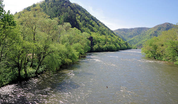
From the parking along Andrews Avenue, walk on Bridge Street (which is the Appalachian Trail) across the railroad tracks. You'll pass the Hot Springs Spa on the left - a great spot for a soak in the mineral waters after the hike (read more). Continue across the bridge over the French Broad River for the view above. Stay on the right side of the bridge.
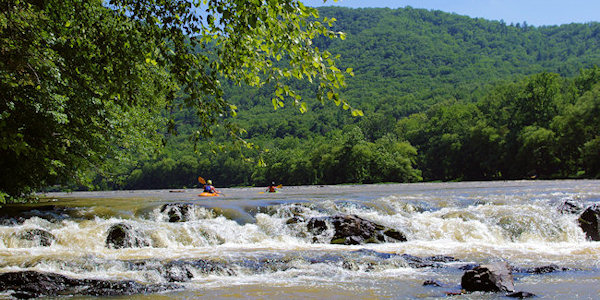
Immediately after crossing the river, there will be a guardrail with a path to the street below. Turn right and go down the stairs to stay on the AT. Follow that street up river about 50 yards until you cross a wooden bridge. Continue along the river by white blazes marking the Appalachian Trail. After a few hundred yards, see Surprise Falls (photo above), a beautiful rapid. The trail continues along the river for a short distance past camping spots. Then the trail heads up the ridge via several switch-backs to ease the climb. The trail is well-marked and well-established.

Atop the ridge, you'll find three rock promontories along the trail with great views of the river, valley and town. Lover's Leap is the second rock outcropping. Take a short but steep walk down to reach the point - be very careful walking on loose rock to the edge. It's a great stopping point for snacks and water. The rocks are jagged, but you can find some spots to sit and enjoy the view.
Return to the trail and continue up the ridge to the third outcropping. Just past it, take a left from the Appalachian Trail to stay on the Lover's Leap trail to Silver Mine. You will walk down the back side of the ridge to the Silver Mine parking area. Take a left on the road to walk back to the bridge where you began the hike (passing by some shabby shacks).
For a longer hike, continue on the Appalachian Trail to Tanyard Gap (where the trail crosses US Highways 25 and 70 east about 3 miles by car). It's a challenging uphill hike of 5.9 miles. If you have two cars, leave one in Hot Springs and drive to Tanyard Gap and hike downhill for 5.9 miles. Bluff Mountain Outfitters offers shuttles.
If you want to soak in the hot mineral springs after your hike, be sure to make reservations in advance. They often book up, especially on weekends.
Driving Directions
From Asheville (36 miles), take I-26 West to Weaverville. Take Exit 19A for US 25 North / US 70 West. Follow signs to Hot Springs. As you enter town, you'll drive across the river bridge and railroad tracks on Bridge Street (photo above). Turn right on Andrews Avenue for parking. For GPS, use address: 25 Andrews Avenue North, Hot Springs, NC.
For other nearby hikes on the Appalachian Trail, go to Max Patch or Rich Mountain. And see more things to do in Madison County.


