Limited-Time Offer: Save $50 on a Biltmore® Annual Pass
Buy Your Pass

Forest Order Effective Now through June 21, 2029: Due to overuse and damage, there is a Forest Order in effect to protect this special place. Please read the restrictions below so you can enjoy Max Patch safely.
Hike a section of the famous Appalachian National Scenic Trail (or A.T.) on top of Max Patch Mountain near Hot Springs. This 4,600-ft. bald mountain was cleared and used as pasture in the 1800s. Today, it's a 350-acre tract of open land on a high knob with 360-degree views. It's one of the most spectacular settings you'll experience in the Blue Ridge.
On a clear day, see Mt. Mitchell to the east and the Great Smoky Mountains to the south. What a picnic spot! And great for star gazing, camping and wildflowers. The summit is a short hike from the parking area deep in Pisgah National Forest. This fragile landscape supports rare plant and animal species. You may be tempted to follow the closed trail that leads from the parking lot straight to the summit, but please resist since it's an ecological restoration area. Follow one of the two easier blue blaze trails to the Appalachian Trail and summit. Hike up one trail, cross the summit and back down the other for a total of 1.7 miles.

To reach the easy loop that crosses the summit, follow the blue blaze trail to the left or right for about a half mile. The intersections with the A.T. are well-marked and blazed white. To extend the hike, head north or south on the Appalachian Trail for as far as you want. Hot Springs is about 20 miles north.
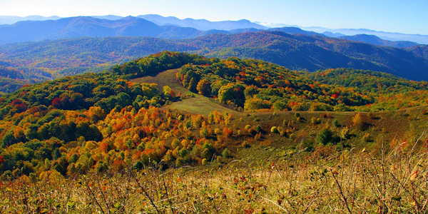
The Great Smoky Mountains, only 20 miles away, dominate the southwest horizon. To the west the terrain drops more than 3,600 ft. into the flatlands of eastern Tennessee. Fifty miles to the west rises the ridgeline of the Black Mountains. Peak fall color is usually the second and third week in October. Drive the nearby Appalachian Medley Scenic Byway to find other nearby things to do.
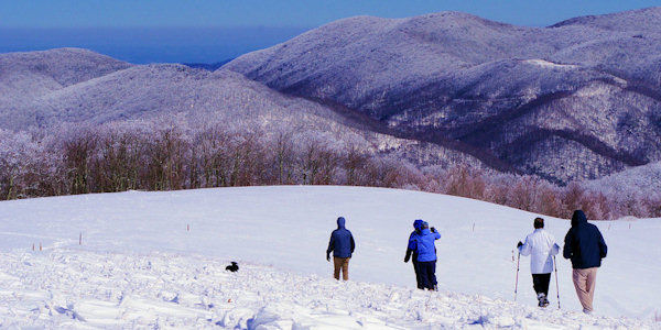
Take along a jacket, since it's usually at least 10 degrees cooler on Max Patch than in Asheville. And it's usually breezy. It can be an absolutely gorgeous winter hike after snow!
Max Patch Restrictions in Place Until June 30, 2026.
- Leave no trace of your visit.
- No camping, no fires, no fireworks.
- Area closes 1 hour after sundown and reopens 1 hour before sunrise.
- No groups larger than 10.
- Dogs must be leashed.
- Stay on designated trails.
- Bikes must stay on roads only.
- No horses and other saddle and pack animals.
- There are no bathrooms at Max Patch. The nearest is a a 20-minute drive away at Harmon Den Horse Camps. Plan accordingly.
- Parking is limited to a small lot and a few designated spots along the road. Improper parking blocks access for emergency vehicles and creates traffic jams.
- Aircraft may not land, drop off, or pick up anything in the area. Drones are prohibited on the Appalachian Trail.
Directions
Since Max Patch is deep in Pisgah National Forest, don't rely on your GPS. There are many unpaved roads in the area that are not signed. These unpaved roads can be bumpy, so not recommended for low-clearance cars. All-wheel drive vehicles are recommended. Follow one of these three routes. Allow about 1 hour 15 minutes to drive from Asheville (45 miles).
Directions via I-40 from Asheville: Take I-40 West about 40 miles to exit 7 (Harmon's Den). Take a right on Cold Springs Road, and the road almost immediately becomes gravel. This usually well-graded road climbs steadily but never steeply 6.2 miles to SR-1182 (Max Patch Road). 4WD recommended in winter and wet weather. Turn left and drive 1.5 miles to the Max Patch parking area on the right. Allow an hour to drive.
Directions via Hot Springs from Asheville: From Asheville, take US 25/70 north to Hot Springs (36 miles). From downtown Hot Springs, follow Highway 209/Appalachian Medley Scenic Byway (7.3 miles) to Meadow Fork Road (State Road 1175). Go 5.3 miles to State Road 1181. Follow 1181 for 2 miles (turns into gravel). At the top of the mountain, turn right onto State Road 1182 and Max Patch parking is 3 miles.
Directions via I-40 from Lake Junaluska: Exit #24 and follow NC 209 North about 8 miles to Fines Creek General Store. Continue straight about 12 miles onto Max Patch Road. The last 8 miles are unpaved and curvy. The obvious parking area will be on your left.
Questions: Phone the Pisgah Forest Ranger station M-F at 828-689-9694.
Soak in the hot mineral springs after your hike!
360 Video of Max Patch Hike
See the following video filmed by our friends at Namaste In Nature! This video was filmed using 360º 5.6K resolution so you may need to adjust your youtube streaming quality to a higher setting for the best experience. These videos work on a desktop but seem to stream better on a mobile device.
Our Quick Video of Max Patch
Google Map to Max Patch
(Reminder - don't rely solely on your GPS in this remote area.)
More Hot Springs Hikes
Lover's Leap Hike: Start from the center of downtown Hot Springs for this one. See our Lover's Leap Hike Guide.
Rich Mountain: Starting three miles from Hot Springs, hike on the Appalachian Trail to Rich Mountain and its Lookout Tower. See our Rich Mountain Guide.
See our Asheville Area Hiking Guide.


