These scenic drives and maps take you to the best waterfall road trips to enjoy in western North Carolina near Asheville, including the Blue Ridge Parkway. We suggest mapping out your trip with our Top 40 Waterfalls Google Map (below) in advance or getting print directions of the 60 Waterfalls we feature. Often, you cannot rely on your GPS to locate these waterfalls (most do not have a street address or even a roadside sign). Mobile phone reception is very weak in many mountain locations. Stay on state or U.S. highways to guarantee you don't end you on a difficult dirt road deep in the mountains!
Asheville Waterfalls Google Map
Waterfall Scenic Drives & Road Trips
Click on the links for an extensive guide and directions to each waterfall.
#1. Asheville / Brevard Loop Waterfall Tour & Scenic Drive: DuPont Forest, Looking Glass, Graveyard Fields
Length: 90 miles round-trip from Asheville
This is our favorite waterfall drive from Asheville with plenty of beautiful mountain scenery along the way, and it's short enough to make a very enjoyable day trip from wherever you are staying near Asheville.
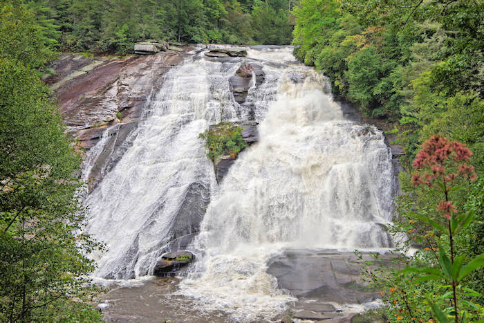
- Begin early in the day and head to DuPont State Forest. From Asheville, take I-26 East to exit 40 for Highway 280/Airport exit toward Brevard. Turn right onto NC Highway 280 and drive about 16 miles. Turn left on U.S. 64 as you enter Brevard past Wal-Mart. Travel east on U.S. 64 for 3.7 miles to the gas station in Penrose. Turn right on Crab Creek Rd, continue 4.3 miles and turn right on DuPont Rd. Ascend and descend; after 3.1 miles, find the Hooker Falls parking lot on the right just before the Little River bridge. Hike to Hooker Falls, Triple Falls, High Falls and Bridal Veil Falls. Movie location for The Hunger Games. Read more.
- Backtrack to Brevard and at the NC 280 intersection, continue STRAIGHT onto US 276 (Forest Heritage National Scenic Byway) into Pisgah National Forest.
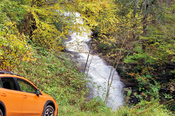
- Drive six miles to Looking Glass Falls (view from roadside).
- Continue about a mile to Moore Cove Falls (1.5 mile roundtrip hike).
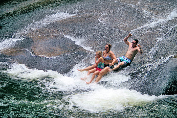
- Continue less than a mile to Sliding Rock and stop if you want to slide down the natural slide.
- Other nearby waterfalls include Daniel Ridge Falls, Cove Creek Falls, Slick Rock Falls, Twin Falls and Log Hollow Falls (near Near the Pisgah Center for Wildlife Education).
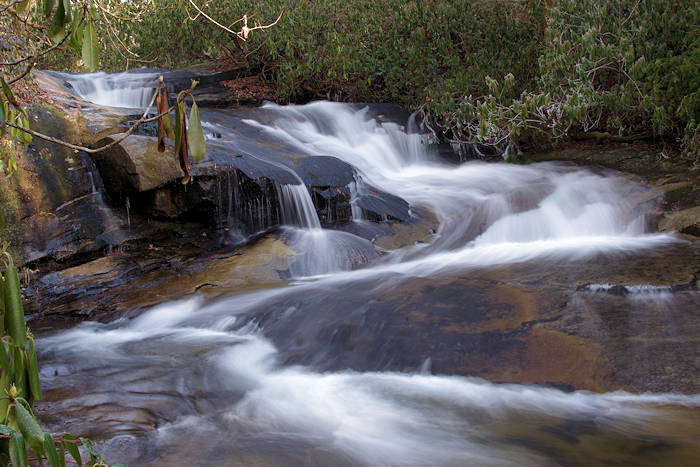
- Continue driving up the mountain ridge to the Blue Ridge Parkway. For the Graveyard Fields waterfall, go south 6.8 miles on the Parkway (hike to Skinny Dip Falls at Milepost 417). Or go north to return to Asheville and one of the most beautiful drives in America.
- See the Pisgah Forest Waterfall & Hiking Map.
#2. Asheville / Highlands Waterfall Tour & Scenic Drive: Gorges State Park, Upper Whitewater Falls, Dry Falls
Length: 170 miles round-trip from Asheville
There are so many waterfalls on this route, it would take you a few days to see them all. Or save a few for your next trip:
- Head toward Brevard by driving I-26 East to exit 40 for Highway 280/Airport exit. Turn right onto NC Highway 280. In Brevard, NC 280 will turn into US 64 West. About three miles on other side of Brevard, you can take a short detour to Cathey's Creek Falls.
- Or continue to Gorges State Park and hike to the beautiful Rainbow Falls and neighboring Turtleback Falls (swimming hole).
- After that, drive to nearby Upper Whitewater Falls, the highest waterfall in eastern America. It's an easy and quick hike to the overlook to view.
- Back on US 64, head toward Cashiers. Schoolhouse Falls in Panthertown Valley is well worth a side trip.
- In Cashiers, detour south four miles to see Silver Run Falls.
- Return to US 64 and continue toward Highlands. Stop at roadside Dry Falls, walk behind the waterfall. Nearby, drive behind Bridal Veil Falls.
- If you have time and energy, hike to Glen Falls in Highlands.
- It's 72 miles to Highlands from Asheville and about half of the drive is curvy mountain roads. So allow plenty of time. Return a faster route to Asheville via Franklin: Follow US 23/441 to US 19/23, most of this drive is expressway and faster, even though it's 84 miles back.
#3. Blue Ridge Parkway Waterfall Drive Tour & Scenic Drive: Linville Falls, Crabtree Falls, Graveyard Fields
Length: 204 miles round-trip from Asheville
This 102-mile stretch of the Blue Ridge Parkway is one of the most beautiful and highest drives in America. In addition to the waterfalls below, there are many great stops along the way, including Mt. Mitchell, Craggy Gardens, Folk Art Center, Mt. Pisgah and many overlooks. This drive can easily fill your day. Remember, to return to your starting point, it is at least a 204-mile trek! To reduce driving time, take a faster route to a starting point on the Parkway and drive it one way.
- Starting north and driving down, Linville Falls is the first stop (at Parkway Milepost 316.3). This is the most photographed waterfall in North Carolina. They have a great Visitors Center, picnic area and campground. Moderate hikes (1 to 1.5 miles) take you to overlooks with spectacular views of the falls and Linville Gorge. One hike takes you to the base of the falls.
- Head south from Linville Falls to Crabtree Falls (Milepost 339.5). Take 2.5-mile hike through the forest to an up-close view of the beautiful 70-ft. Crabtree Falls.
- Optional: Exit onto NC Highway 80 North and go two miles for Roaring Fork Falls and Setrock Creek Falls.
- Stop for a quick look of Glassmine Falls at the overlook at Milepost 362.1. After rainy weather, this waterfall gives a quite impressive vista across the valley.
- The next waterfall is 50 miles down the Parkway (see other stops along the way on our Blue Ridge Parkway Guide), with plenty of beautiful mountain scenery along the way. At Milepost 412, US 276 crosses the Parkway. Take a detour south on the Forest Heritage Scenic Byway to Sliding Rock (8 miles) and Looking Glass Falls (10 miles). Or continue on Parkway to your next stop.
- At the Looking Glass Rock Overlook at Milepost 417, there is a 1/2-mile hike to Skinny Dip Falls, a popular summer swimming spot and beautiful setting any time of the year.
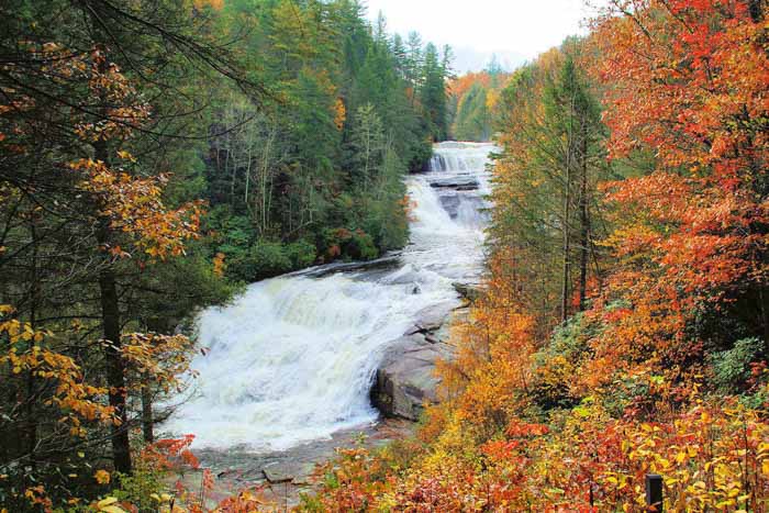
- The last stop is Graveyard Fields at Milepost 418.8, with hiking trails through a highland meadow that takes you to two waterfalls. The most beautiful is just 1/3 mile from the parking area!
- Driving to the end of the Parkway near Cherokee? Just one mile from Milepost 455.7 (on U.S. Highway 19 south) is Soco Falls.
#4. Great Smoky Mountains Waterfalls: Soco Falls, Mingo Falls, Deep Creek
Length: 44 miles
Begin in the Maggie Valley area (about 35 miles west of Asheville) and head toward the Great Smoky Mountains National Park! Stop in Maggie Valley for great shopping or tour the amazing Wheels Through Time, a museum of motorcycles and automobiles. You will also go through Bryson City and Cherokee, with much to see along the way.
- From Maggie Valley, drive south on U.S. Highway 19 toward Cherokee. In just a few miles, you will pass the Blue Ridge Parkway. 1.5 miles past the Parkway, look for a small parking area on the left for Soco Falls (no signs there!). It's a short walk to an observation deck. To reach the base of the twin waterfall, carefully climb down a very steep trail.
- Turn around and go back to the Blue Ridge Parkway and go south on the Parkway toward the Great Smoky Mountains. Ride the Parkway for about 13 miles to the end near the Park entrance. Turn left on US 441 South, then left onto Big Cove Road in about 3/4 mile. Drive about five miles to Mingo Falls.
- Go back toward Cherokee and left onto US 441 South. After you go through Cherokee, turn right onto U.S. 19 South to Bryson City. Before you reach downtown Bryson City, turn right onto Deep Creek Road to the Great Smoky Mountains National Park. It's only about 2.5 miles to the Deep Creek Campground inside the Park, with the parking area for the hiking trail along the creek to Indian Falls, Toms Branch Falls and Juney Whank Falls.
- Drive back to downtown Bryson City for some great restaurant choices. To return to the Asheville area (60 miles by faster freeway), take U.S. Highway 74 east to I-40 West.
#5: NC Highway 215 Waterfalls
Length: 20.7 miles
Begin at US Highway 64 west of Brevard at the intersection of NC Highway 215, part of the Forest Heritage Scenic Byway, and travel north toward and past the Blue Ridge Parkway. You can return to Asheville via the Blue Ridge Parkway.
- At 7.5 miles, stop to see three waterfalls, including roadside twin waterfalls French Broad and Shoals Creek.
- At 10.2 miles, take a detour in Pisgah National Forest to the hike to Courthouse Falls.
- At 14 miles, take another detour to see Dill Falls and Upper Dill Falls in Nantahala National Forest.
- At 17.3 miles (about 8/10 of a mile past the intersection with the Blue Ridge Parkway), take a hike to Wildcat Falls.
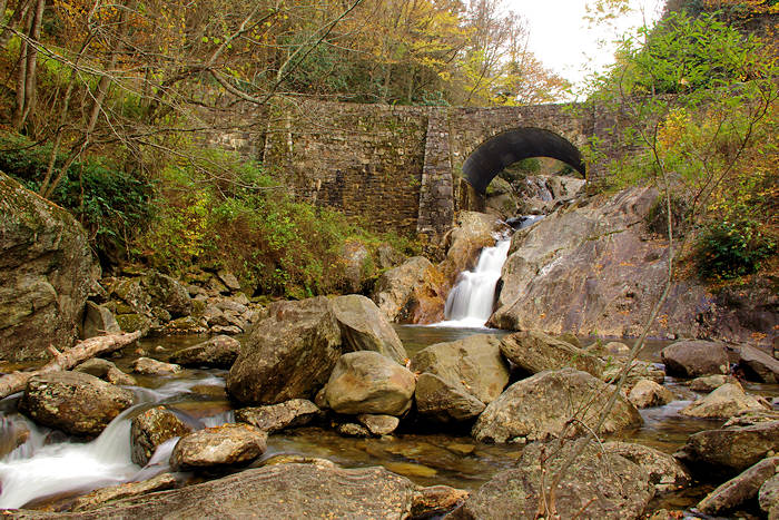
- At 20.7 miles, stop at the historic stone bridge over the Pigeon River to see Sunburst Falls.
#6. Chimney Rock Waterfall Tour: Catawba Falls, Hickory Nut Falls, Pearson's Fall
Length: 64 miles
Begin this tour in Old Fort, 24 miles east of downtown Asheville on I-40. Then travel south to Chimney Rock and Lake Lure area, and on to Saluda. Both Chimney Rock and downtown Saluda have great shopping and dining options. Or stop in downtown Hendersonville along the way.
- From I-40, drive three miles from the Old Fort exit into the Pisgah National Forest to Catawba Falls. Take a beautiful 1.5-mile hike to the waterfall. (If you are a very experienced hiker and good at climbing up rocks and a very steep trail, continue to the upper falls.)
- Return to I-40 and go west to Black Mountain and take NC Highway 9 South to Bat Cave. This twisty scenic 17-mile drive is known as the Black Mountain Rag, named for an old fiddle tune about the dark green Lauada Firs that give the Black Mountains their name. In Bat Cave, turn left onto U.S. Highway 74 to Chimney Rock Park. Park admission is required to drive up to the parking area for the hike to Hickory Nut Falls, a 404-ft. waterfall that is most impression after rainy weather. 32 miles.
- From Chimney Rock, drive back to Bat Cave and follow U.S. 64 East to Hendersonville, through apple orchard country. Go east on I-26 to exit 59 for Saluda and drive a few miles on US Highway 176 toward Tryon to Pearson's Falls.
- For a roadside waterfall about 10 miles from Pearson's Falls, see Shunkawauken Falls.
Guided Waterfall Tours
Asheville Waterfall Map #2