
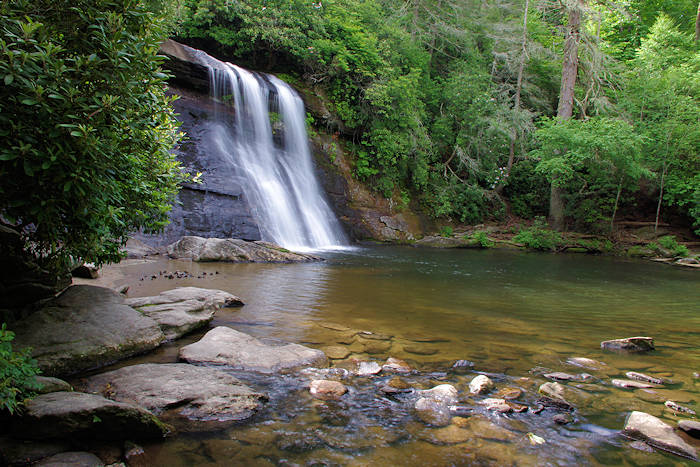
Schoolhouse Falls is not a tall waterfall (drops about 20 ft.), but it makes up for that in beauty! It's the most popular of the many waterfalls in Panthertown Valley in the Nantahala National Forest, located in Jackson County (55 miles from Asheville). The cascade freefalls into a refreshing pool that is safe for swimming and wading. Since there is a network of trails in the Valley, you have a variety of hike options. The most direct route is 2.5 miles roundtrip. Our favorite is a loop hike that includes mountain views from a stone-covered summit and a second waterfall (Greenland Creek Falls). Feature photo by Tonya Engelbrecht.
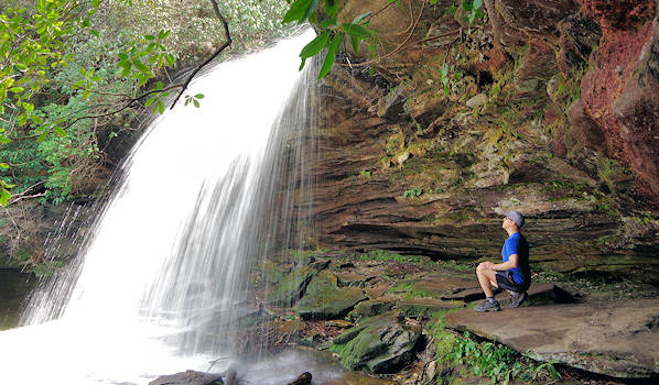
You can walk behind Schoolhouse Falls during lighter water flows. Approach via a skinny trail on the right side of the pool. Be careful of slippery rocks and don't disturb sensitive plant-life behind the waterfall.
The falls are named for a schoolhouse that was nearby when the valley was populated. In Panthertown Valley, you will find granite rock domes with 300-ft. cliffs, deep gorges, broad valleys, bogs, trout streams and waterfalls. Hike, mountain bike or ride a horse on 30 miles of maintained trails. Camping is permitted, but groups are limited to no more than 12 people per site. Bring food in bear-proof canisters since local bears know to find food at campsites.
The Hike
Signs to and at Panthertown are limited. So take these directions or pick up a map at the Highland Hiker in Cashiers. The 2.5-mile round-trip hike from the Cold Mountain Gap parking area (directions below). Begin the hike to the right of the kiosk with a posted trail map. This will take you downhill to the main Pantertown Valley Trail #474, which is an old logging road, and easy to follow with a gradual descent (so uphill on the way back). You'll pass the Devil's Elbow Trail on the right. This section is about a mile. Turn left on Little Green Trail #485. This follows the creek for a few minutes up to Schoolhouse Falls.
After you enjoy the waterfall, return the same route or continue on the Little Green Trail to cross Green Mountain and see another waterfall for a more strenuous 5-mile loop.
Green Mountain & Tranquility Point 5-Mile Loop
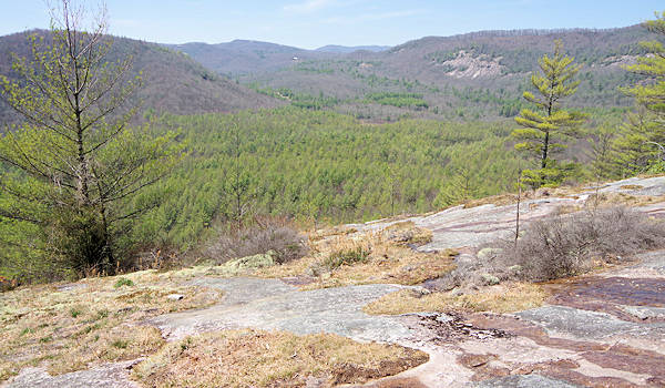
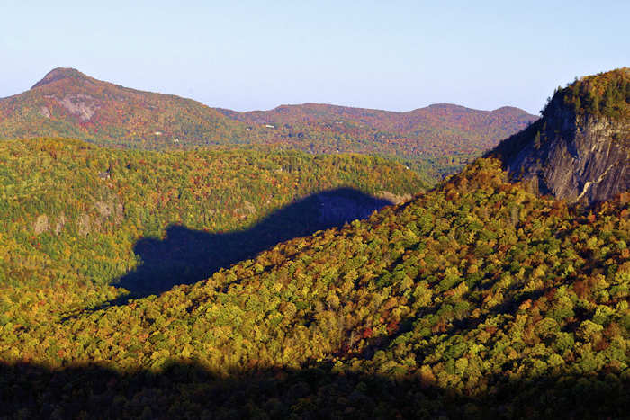
After enjoying Schoolhouse Falls, continue on Little Green Trail (green blazes) up to the summit of Little Green Mountain (elevation 4,040 ft). Walk uphill to gain about 600 ft. in elevation to reach exposed sections of granite with many spots for great views. The largest exposed area is called Tranquility Point (photo above) - another great spot for a picnic! Alert: Following the trail across the summit can be tricky on the expanse of granite. Be sure to follow the green blazes on trees or the faint white arrows on the rock under your feet. You'll go through several open areas before the trail descends on the other side. There are many side trails up here that lead to camping spots. Look for a green blaze (metal rectangle nailed to a tree) to make sure you head down the mountain on the correct trail.
After descending Green Mountain, reach the intersection of Mac's Gap Trail #482. Turn left (red blazes) and go about a mile up and down a ridge to Greenland Creek (wet crossing). It's shallow and the bottom is covered with smooth stones. Pull off your shoes and walk across (nice refreshment for the hiking feet). Some of the rocks can be slippery, so be careful.
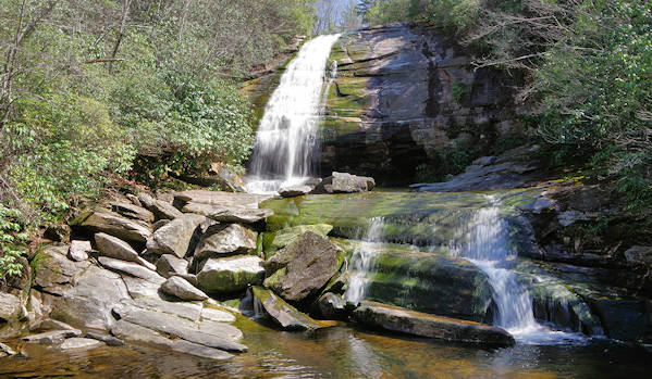
Just on the other side of the creek, turn right onto Greenland Creek Trail and take the winding, skinny trail through rhododendron to the 60-ft. Greenland Creek Falls. At the end, you climb over some big rocks and fallen trees to get a great view. (If you just want to visit Greenland Creek Falls, hike the Greenland Creek Trail from the parking area for a 2.5-mile roundtrip hike.)
Return to Mac's Gap Trail and continue straight about a mile to the Cold Mountain Gap parking area where you parked, completing your loop. The trail ends at the gravel entrance road, so follow it to the left a short distance to the parking area. You can also hike back via Greenland Creek Trail - it's just a little longer and you follow the creek with other cascades (Mac's and Pothole Falls).
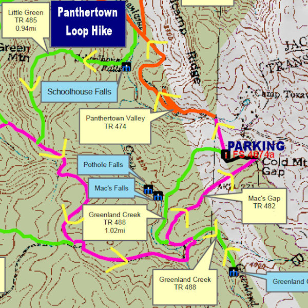
Save JPEG of the full map to your phone. Download a PDF of the trails map.
Directions: East Entrance (Cold Mountain Gap)
(GPS 35.157843, -82.998909)
From Asheville, take US Highway 64 West toward Brevard and Lake Toxaway. Near Lake Toxaway, turn right onto NC Highway 281 North for 8/10-mile to "Cold Mountain Road" on your left (just past Lake Toxaway Fire Station). Drive Cold Mountain Road about six miles up the mountain. It becomes gravel near the end. At a sharp left turn, a sign will indicate the Panthertown parking is just ahead. (56 miles from downtown Asheville)
Ranger Office
There are no facilities, ranger offices or visitor centers at Panthertown. For questions, contact the Nantahala Ranger District in Franklin at 828-524-6441.
Check out this 360 video of Schoolhouse Falls View by our friends at Hike NC With Me